Natural Gas System Survey, HAAF, Savannah, GA
Hunter Army Airfield (HAAF), a member of Team Stewart (Fort Stewart, HAAF, and Kelly Hill), plays a critical role in supporting the 3rd Infantry Division (3rd ID) and the nations power project requirements. The Directorate of Public Works (DPW) is charged with maintaining the installations infrastructure to support the mission, troops, and families of the 3rd ID.
The HAAF natural gas system is a primary utility infrastructure and critical asset that requires reliable high confidence data. Inaccurate data has contributed to numerous service interruptions and related management issues. The DPW tasked Spatial Engineering (SPATIAL) to perform a comprehensive survey of the natural gas system. Since 98% of the natural gas system is underground, SPATIAL added GEL Geophysics, LLC, a leader in Subsurface Utility Exploration (SUE). The unique team (SPATIAL-GEL) combined expertise in field data collection, data processing, asset inventory and data management to complete the following:
- Project site is approximately 1,577 acres with approximately 57,192 linear feet of natural gas line
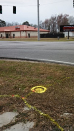
- Used ground penetrating radar (GPR) augmented with seventeen (17) vacuum excavation test holes to identify underground gas pipe locations
- On average, GPR survey locations were within 6-inches of actual location as verified with the test holes. Based on these findings, survey accurate to 0.5 feet or better at the 95% confidence level
- Survey indicated existing natural gas system inventory and as-builts were inaccurate
- Discovered an additional 83 (+922%) regulators, 9210 (+19.2%) linear feet of pipe, 65 (+464%) meters, and 30 (+63.8%) valves
- Photos taken of each surface feature and included with the database
- SDSFIE feature classes in accordance with the IMCOM IGI&S Quality Assurance Plans (QAP) for Natural Gas. The Natural Gas Line QAP includes 46 data checks
The geophysical techniques used to locate the natural gas features in the field provide the Fort Stewart/HAAF DPW a 95% confidence in the mapping to actual location of the natural gas system. The data reconciliation techniques provide a 100% confidence in QAP compliance and data linkage in the delivered geodatabase, test hole logs, and surface feature photos. Data loaded directly into the installation IGI&S database.
Accomplishments
• GPS Field Survey – 6” Accuracy at 95% Confidence
• Ground Penetrating Radar (GPR)
• Data Reconciled to As-Builts
• 46 IGI&S QAP Checks – 100% Confidence
• SDSFIE FGDC Metadata